
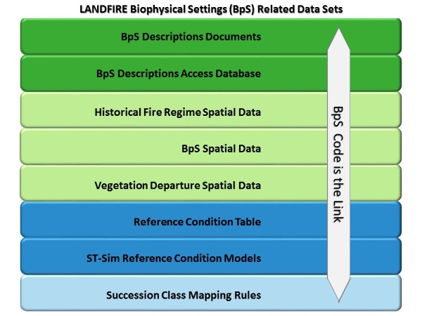
Understanding the BpS Model Products
The LANDFIRE BpS Model Suite includes the following non-spatial products, which you can find details for in the subsequent sections of this page:
- State-and-transition simulation models
- Description documents
- Succession class mapping rules
- Reference conditions
In addition, several LANDFIRE geospatial products were developed using model-related information.
- Deciphering the BpS Code (PDF)
- Linking the BpS Models & Descriptions (PDF)
- What are Map Zones? (PDF)
State-and-Transition Simulation Models
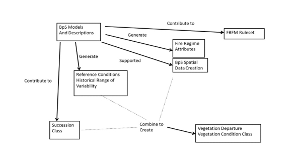
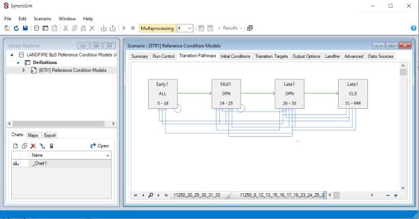
LANDFIRE’s state-and-transition simulation models provide a quantitative representation of the growth and disturbance dynamics of each BpS. LANDFIRE uses the model results to estimate reference conditions (see below) for every BpS. Managers can use the models to do this and much more, including testing potential management strategies, impacts of old or new stressors and documenting knowledge. The LANDFIRE BpS Models are developed and manipulated in SyncroSim, a free modeling software. In addition to the software, users need the ST-Sim package to access the models. LANDFIRE recommends that users obtain the landfirevegmodels package to get the most current model library and access additional functions specific to LANDFIRE models.
Description Documents
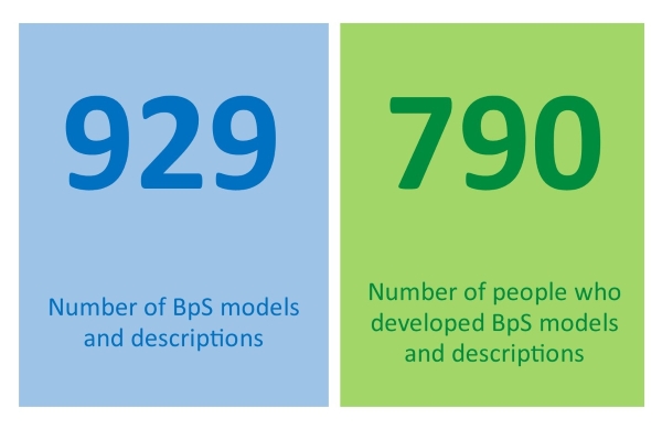
A description document (delivered as a Microsoft Word file) accompanies every BpS model and is linked to the relevant model via the BpS code. This accompanying narrative is intended to describe the vegetation concept the developer was modeling and add important details that are not present in the model itself. The description includes information on dominant species, explains the model parameters, and defines each modeled state, including its structure and composition. The description document includes the names of individuals who contributed to model development and review and incorporates important caveats and comments from reviewers to provide a more complete picture of the BpS.
Succession Class Mapping Rules
The modeled states in a BpS state-and-transition simulation model are referred to as succession classes (SClass). The BpS description document describes each succession class and provides a set of mapping rules so the current location of every state can be mapped in the Succession Classes geospatial product. LANDFIRE also delivers a succession class mapping rules spreadsheet. The spreadsheet contains rules for mapping the states of every BpS including additional mapping criteria that are not included in the description document. We suggest that users refer to the rules in the description document to get a basic understanding of succession class structure. Users that need a complete and detailed ruleset should use the mapping rules spreadsheet.
Reference Conditions
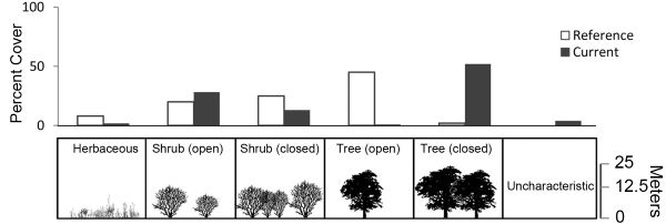
LANDFIRE produces a set of vegetation and fire regime reference conditions for every BpS. Vegetation reference conditions estimate the relative proportion of each succession class. Fire regime reference conditions estimate the frequency and severity of fire within a BpS. LANDFIRE calculates reference condition values from the state-and-transition simulation model results.
The figure on the right compares the reference and current conditions for an Ozark Oak Woodland BpS. Reference conditions are estimated from the results of the LANDFIRE state-and-transition simulation model. Current conditions are mapped in the LANDFIRE Succession Class geospatial layer. LANDFIRE compares vegetation reference conditions with current conditions to calculate Vegetation Departure (graphic from Swaty et al. 2011).
Related Geospatial Products
LANDFIRE used the BpS models and descriptions to create several other products. The BpS description documents describe the BpS concepts and helped LANDFIRE mapping teams create the BpS geospatial product. The descriptions also contain the rules for mapping each modeled state in the succession classes geospatial product. BpS model results are used to estimate reference conditions for vegetation and fire regimes. The reference conditions are a stand-alone product (see Reference Conditions above), and the fire regime reference conditions are included as attributes of the BpS geospatial product. To create the vegetation departure geospatial product, LANDFIRE compares the current succession class amount, calculated from the succession classes geospatial product, to the reference succession class amount reported in the reference conditions. These related datasets help users integrate historical and current information in their decision making.